The Trip
On Wednesday (5/17) our class took a field trip to the Batelle Darby Metropark, in order to look more closely at some of our local Ohio flora. I was tasked with documenting multiple species limestone loving plants, some invasive species, and a personal quest to find plants that utilize animals in their dispersal.
The Limestone Lovers
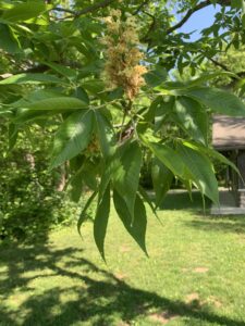
OH-IO! Our state tree, the Ohio Buckeye (Aesculus glabra)! The nuts may be poisonous but don’t let that stop you from picking them up and making a beautiful necklace out of them!

The Ohio Spiderwort (Tradescantia ohiensis) is one of the more interesting plants I saw on the trip, mainly for its arachnid like qualities. It’s leaves can be used to treat insect bites.
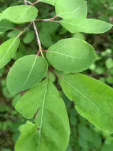
Blackhaw (Viburnum prunifolium) is a species native to eastern North America. It’s fruits can be made into preserves, which I hear have a sweet/smokey taste? Definitely something I need to try one day.
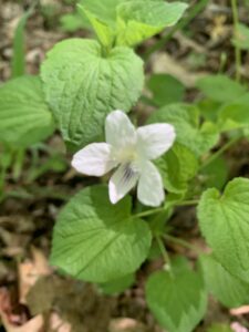
Cream violet (Viola striata) was a beautiful wildflower found while hiking the trails. It’s leaves have a high amount of vitamin C and its flowers are commonly used to decorate cakes!
Invasive Species
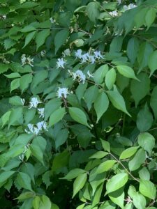
Honeysuckle (Lonicera caprifolium) is an invasive species originating from parts of Asia and Russia. It was introduced in the U.S. predominantly as an ornamental.
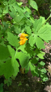
Celandine Poppy (Stylophorum diphyllum). Hailing from Europe, it is assumed it was brought over for its ornamental qualities. Celandine, an herbal medicine made from the celandine poppy is used to treat stomach, liver, and gallbladder problems.
Animal dispersal
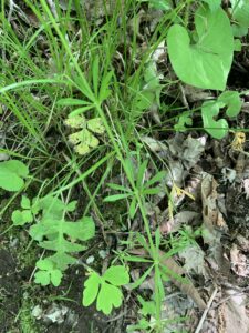
Galium aparine, also known as cleavers, clivers, catchweed “robin-run-the-hedge”, and my favorite sticky willy. If your not plucking and throwing it on your friends (it’s specialized hairs give it that “sticky” quality) it is entirely edible!
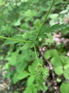
If we look closely at this Spring Avens (Geum vernum), we can barely make out the tiny hairs at the tip of the plant. These hairs latch onto any passing animal, transporting the seeds to a different location.
Jane Forsythe’s New Field of “Geobotany”
Before arriving at the Metro Park, I was given a short article to read by Jane Forsythe titled, “Linking Geology and Botany…A New Approach”. In it, Jane discusses both of the aforementioned fields of study and attempts to utilize both in understanding the overall ecology of Ohio.
(1) When considering the geology of Ohio in broad terms, it can indeed be divided into two distinct regions: the eastern part and the western part. While this division is somewhat simplistic, it provides a general understanding of the geological characteristics of the state. Let’s contrast these two parts in terms of their geographic location, underlying rocks, physical properties, and landscape/topography:
Eastern Ohio:
-
- Geographic Location: The eastern part of Ohio borders the Appalachian Mountains and is situated in the Allegheny Plateau region.
- Underlying Rocks: This region primarily consists of sedimentary rocks, such as shale, sandstone, limestone, and coal deposits.
- Physical Properties: They are generally softer and more easily eroded compared to the rocks found in the western part of the state.
- Landscape/Topography: Eastern Ohio is characterized by rolling hills, dissected plateaus, and numerous river valleys. The region exhibits a more rugged and varied topography due to erosion and uplift associated with the Appalachian Mountains.
Western Ohio:
-
- Geographic Location: Western Ohio lies within the Central Lowlands region, which is part of the Interior Plains of North America.
- Underlying Rocks: The geology of western Ohio primarily comprises flat-lying sedimentary rocks, including limestone, dolomite, and sandstone.
- Physical Properties: The sedimentary rocks in western Ohio tend to be more resistant to weathering and erosion compared to those in the eastern part. They form a relatively stable and flat landscape.
- Landscape/Topography: Western Ohio is characterized by gently rolling plains and flat agricultural land. The topography is generally more subdued and less rugged compared to eastern Ohio. The region features fertile soils, extensive farmlands, and relatively fewer natural features like hills or valleys.
It’s important to note that the geology of Ohio is more complex than this broad division implies, with variations and transitions between the two regions.
(2) The original sequence of sedimentary rock strata, from top to bottom, typically consists of the following three types:
- Shale: Shale is a fine-grained sedimentary rock formed from the compaction of mud and clay particles. It is usually found at the top of the sequence and is characterized by its laminated structure and ability to split into thin layers.
- Sandstone: Sandstone is a coarse-grained sedimentary rock composed mainly of sand-sized mineral particles or rock fragments. It commonly occurs below shale layers and is known for its porous nature and ability to hold water.
- Limestone: Limestone is a sedimentary rock primarily composed of calcium carbonate. It often forms at the bottom of the sequence and is typically formed from the accumulation of marine shells or coral reefs. Limestone is known for its hardness and can often contain fossils.
Regarding the arch that formed 200 million years ago, the crest of the arch would have been located at a higher elevation compared to the low-lying toe. This formation is known as an anticline, which is a fold in the Earth’s crust with the oldest rocks in the core and the youngest rocks on the flanks. The crest of the arch would represent the highest point, while the toe would be the lowest point.
An important river system that occupied Ohio for a long time is the Ohio River. The Ohio River has been flowing for thousands of years, shaping the landscape of the region. It is approximately 981 miles (1,579 kilometers) long and has had a significant impact on the geography and development of the surrounding areas.
Over time, the Ohio River has carved out a broad valley, creating steep-sided riverbanks and contributing to the formation of floodplains. The river’s continuous flow and erosion have shaped the land, transporting sediment and depositing it along its course. The river has been an important transportation route, supporting trade and commerce in the region.
However, the activities of the Ohio River were curtailed by the construction of dams and reservoirs. These man-made structures were built to regulate the river’s flow, provide flood control, and generate hydroelectric power. The dams have created reservoirs, altering the natural flow of the river and impeding its ability to shape the landscape as it once did.
(3) The feature of the landscape that slowed the Pleistocene glaciers and caused a glacial boundary to cut across Ohio is known as the Ohioan Moraine. During the Pleistocene epoch, which lasted from about 2.6 million to 11,700 years ago, a series of glaciations occurred, resulting in the advancement and retreat of massive ice sheets.
As the glaciers advanced southward into what is now Ohio, they encountered a region with varying topography and geology. The presence of the Appalachian Plateau, a relatively elevated area in eastern Ohio, played a significant role in slowing down the glaciers. The resistant rocks and elevated terrain of the Appalachian Plateau caused the ice to be deflected and diverted around this region. We can see the location of the glacier boundary with this Sketch of ohio.
(4) Glacial till refers to unsorted and unstratified sediment deposited by glaciers during their movement and subsequent melting. It is a type of glacial drift, which encompasses all the materials transported and deposited by glaciers. Till is characterized by its heterogeneous nature and contains a wide range of particle sizes, ranging from clay and silt to sand, gravel, and even boulders.
The general composition of glacial till can vary depending on the geological characteristics of the region where it is deposited. In the case of eastern and western Ohio, there are some differences in the composition of the glacial till due to variations in the sources of the glacial material.
In eastern Ohio, glacial till primarily consists of a mixture of clay, silt, sand, and gravel. The till in this region tends to be more clay-rich, which is a reflection of the glaciation history and the composition of the bedrock in the area. The glaciers that covered eastern Ohio during the last Ice Age carried and deposited fine-grained sediments, resulting in the predominance of clay and silt in the till.
On the other hand, in western Ohio, the glacial till composition includes a higher proportion of sand, gravel, and larger stones. This is because the glaciers that advanced into this region originated from the north and northwest, where they encountered and eroded sedimentary rocks composed of sandstones and conglomerates. As a result, the till in western Ohio contains more coarse-grained material.
Overall, while glacial till in both eastern and western Ohio consists of a mixture of clay, silt, sand, and gravel, the relative proportions of these components differ. Eastern Ohio’s till tends to be more clay-rich, while western Ohio’s till has a higher content of sand, gravel, and larger stones due to the influence of different glacial sources.
(5) In terms of the basic substrate for plants, there are some contrasting characteristics between western and eastern Ohio, particularly regarding drainage, aeration, pH, and nutrient availability.
- Drainage and Aeration: In general, western Ohio tends to have better natural drainage compared to eastern Ohio. This is because western Ohio lies within the Great Miami Buried Valley, which was formed by glacial meltwater and has well-drained soils. The soils in this region are typically loamy and have good permeability, allowing water to drain more easily. As a result, the substrate in western Ohio provides better aeration for plant roots.
In contrast, eastern Ohio has more varied drainage conditions. This region consists of a mixture of glaciated and unglaciated areas. Glacial till in eastern Ohio tends to have lower permeability, leading to poorer drainage. This can result in waterlogging in some areas, particularly where the glacial till is clay-rich. Consequently, the substrate in eastern Ohio may have reduced aeration compared to western Ohio.
- pH (Limey versus Acid): The pH of the substrate also differs between western and eastern Ohio. Western Ohio generally has soils with a higher pH, often referred to as “limey” or alkaline soils. This alkaline nature is influenced by the underlying bedrock, which contains limestone and other carbonate minerals. As a result, the substrate in western Ohio tends to be more basic or alkaline in pH.
In contrast, eastern Ohio has a more varied range of soil pH. The substrate can be slightly acidic to neutral, depending on the underlying geology and the composition of the glacial till. Acidic soils are more commonly found in areas where the glacial till is derived from sandstone or shale bedrock.
- Nutrient Availability: Nutrient availability can also vary between western and eastern Ohio due to differences in soil composition and pH. Western Ohio’s limey soils tend to have higher natural fertility and nutrient availability. The alkaline pH in this region promotes the release of essential plant nutrients such as calcium, magnesium, and potassium. Consequently, the substrate in western Ohio may offer better nutrient availability for plant growth.
Eastern Ohio, with its more acidic soils, may have lower natural fertility and nutrient availability. Acidic soils tend to have reduced availability of certain nutrients, such as calcium and magnesium. However, it is worth noting that nutrient availability can be influenced by various factors, including soil management practices and the addition of fertilizers.
It’s important to keep in mind that these general characteristics can vary within specific locations in both eastern and western Ohio. Local variations in soil composition, geology, and land use practices can significantly influence the specific conditions and characteristics of the substrate for plants in a given area.
(6) Several tree and shrub species have a distribution that is generally limited to limestone or limey substrates, such as Ohio’s Lake Erie islands. Here are five examples:
- Eastern Redbud (Cercis canadensis): Eastern Redbud is a small deciduous tree that thrives in limestone-rich soils. It is known for its beautiful pink or purple spring flowers and heart-shaped leaves. It is often found growing on limestone bluffs and rocky slopes.
- American Bladdernut (Staphylea trifolia): American Bladdernut is a deciduous shrub that prefers calcareous soils. It produces clusters of white flowers in spring and interesting bladder-like seed capsules. It is commonly found growing along limestone stream banks and rocky habitats.
- Kentucky Coffee Tree (Gymnocladus dioicus): Kentucky Coffee Tree is a large deciduous tree that is adapted to alkaline and limestone soils. It has compound leaves and produces large brown pods containing seeds that were historically used as a coffee substitute. It can be found growing in limestone-rich habitats.
- Allegheny Serviceberry (Amelanchier laevis): Allegheny Serviceberry, also known as Smooth Serviceberry, is a deciduous shrub or small tree that often occurs on calcareous soils. It produces showy white flowers in spring and edible berries that are enjoyed by birds and wildlife. It is commonly found in limestone areas, including the Lake Erie islands.
- Dwarf Hackberry (Celtis tenuifolia): Dwarf Hackberry is a small deciduous tree that prefers calcareous or alkaline soils. It has small, ovate leaves and produces small, berry-like fruits. It can be found growing in limestone outcrops and other limey habitats.
(7) Here are five species of trees/shrubs that have a distribution generally limited to high-lime, clay-rich substrates developed in the thick glacial till of western Ohio:
- Shagbark Hickory (Carya ovata): Shagbark hickory is a large deciduous tree known for its distinctive shaggy bark. It can tolerate clay soils and is often found growing in the limestone-rich regions of western Ohio.
- Ohio Buckeye (Aesculus glabra): The Ohio buckeye is a small to medium-sized deciduous tree that is native to Ohio and surrounding regions. It thrives in clay-rich soils and is well adapted to the limestone-derived substrates found in western Ohio.
- Pawpaw (Asimina triloba): The pawpaw is a small deciduous tree or shrub that produces edible fruits. It prefers well-drained, fertile soils, including clay-rich substrates found in western Ohio. It is the largest edible fruit indigenous to the United States.
- American Hornbeam (Carpinus caroliniana): Also known as musclewood or blue beech, the American hornbeam is a small, understory tree that grows in moist, clay-rich soils. It can be found in various regions of Ohio, including western parts of the state.
- Witch Hazel (Hamamelis virginiana): Witch hazel is a deciduous shrub or small tree that thrives in a range of soil types, including clay-rich substrates. It is known for its showy yellow flowers that bloom in the late fall. Witch hazel can be found in western Ohio, particularly in moist woodlands.
(8) Here are five species of trees/shrubs that have a distribution generally limited to sandstone hills of eastern Ohio:
- Eastern Redbud (Cercis canadensis): Eastern redbud is a small deciduous tree that is known for its stunning pink flowers that bloom in early spring. It is often found growing on sandstone hills in eastern Ohio, where it thrives in well-drained soils.
- Allegheny Chinquapin (Castanea pumila): The Allegheny chinquapin is a shrub-like tree that belongs to the chestnut family. It is typically found on sandstone hills in eastern Ohio and has serrated, glossy leaves and spiny burrs that contain edible nuts.
- Eastern White Pine (Pinus strobus): The eastern white pine is a tall evergreen tree that can reach impressive heights. While it is widely distributed across eastern North America, it can be commonly found on sandstone hills in eastern Ohio, where it adapts well to the well-drained soils.
- Shumard Oak (Quercus shumardii): Shumard oak is a large deciduous tree that thrives in sandy soils and is often found on sandstone hills in eastern Ohio. It has deeply lobed leaves and produces acorns, providing valuable food for wildlife.
- Sand Cherry (Prunus pumila): The sand cherry is a shrub native to eastern North America and is well adapted to sandy soils, including those found on sandstone hills in eastern Ohio. It produces small, edible cherries and displays attractive white flowers in spring.
(9) The major determinants of the distribution of each of these species, in contrast with one another, are as follows:
a) Sweet Buckeye (Aesculus flava): The distribution of sweet buckeye is primarily determined by soil moisture and drainage conditions. It prefers well-drained soils, often found on slopes or ridges, and is typically found in upland areas. Sweet buckeye is more tolerant of drier conditions compared to hemlock, allowing it to thrive in areas with lower soil moisture.
b) Hemlock (Tsuga canadensis): The distribution of hemlock is strongly influenced by shade tolerance and soil moisture. Hemlock is a shade-loving species and is often found in cool, moist environments, such as ravines or sheltered slopes. It requires consistently higher soil moisture levels compared to sweet buckeye, making it less tolerant of dry or well-drained sites.
c) Rhododendron: The distribution of rhododendron is primarily determined by soil acidity and moisture availability. Rhododendrons prefer acidic soils with good moisture retention. They are commonly found in areas with higher rainfall, such as moist woodlands or along streams. Rhododendrons are less tolerant of alkaline soils, which limits their distribution in regions with higher soil pH levels.
